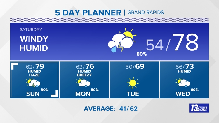
WZZM13 Forecast
Weather News
- Warmer weekend ahead, with periodic thunderstorm chances
- Midwest tornadoes flatten homes in Nebraska suburbs and leave trails of damage in Iowa
- West Michigan orchards fighting below-freezing temps to protect crops
- Kent County emergency manager explains why tornado sirens went off overnight
- Cold Night Expected: Early season flowers and fruit trees at risk
10-Day Forecast
Sun
Apr 28
75
62
60%
14
MPH
SSE
Rain and thunder. Highs in the mid 70s and lows in the upper 50s.
64%
Moderate
6:39 AM
8:40 PM
Mon
Apr 29
76
50
60%
15
MPH
SW
Rain and thunder. Highs in the low 70s and lows in the upper 40s.
69%
Moderate
6:38 AM
8:41 PM
Tue
Apr 30
69
52
0%
15
MPH
W
Partly cloudy. Highs in the upper 60s and lows in the low 50s.
60%
High
6:36 AM
8:42 PM
Wed
May 01
73
49
80%
14
MPH
W
Times of sun and clouds. Highs in the mid 70s and lows in the upper 50s.
60%
High
6:35 AM
8:44 PM
Thu
May 02
66
52
40%
14
MPH
SSE
Scattered thunderstorms. Highs in the upper 70s and lows in the upper 50s.
59%
Moderate
6:34 AM
8:45 PM
Fri
May 03
66
48
40%
13
MPH
WSW
Scattered thunderstorms. Highs in the upper 60s and lows in the low 50s.
57%
Moderate
6:32 AM
8:46 PM
Sat
May 04
65
52
0%
13
MPH
S
A few morning showers. Highs in the low 60s and lows in the upper 40s.
52%
High
6:31 AM
8:47 PM
Sun
May 05
67
50
0%
13
MPH
SSW
Mix of sun and clouds. Highs in the low 60s and lows in the mid 40s.
57%
High
6:30 AM
8:48 PM
Mon
May 06
68
43
0%
11
MPH
W
Times of sun and clouds. Highs in the low 60s and lows in the mid 40s.
55%
High
6:28 AM
8:49 PM
Hourly Forecast
8 PM
Sat
76°
9%
16
MPH
SSW
9 PM
Sat
73°
14%
14
MPH
SSW
10 PM
Sat
72°
17%
14
MPH
SSW
11 PM
Sat
71°
32%
13
MPH
SW
12 AM
Sun
69°
33%
12
MPH
SW
1 AM
Sun
68°
44%
11
MPH
SW
2 AM
Sun
67°
51%
10
MPH
SW
3 AM
Sun
65°
67%
9
MPH
SW
4 AM
Sun
64°
66%
7
MPH
SW
5 AM
Sun
63°
74%
7
MPH
SW
6 AM
Sun
63°
82%
7
MPH
SW
7 AM
Sun
63°
81%
8
MPH
SW